Wednesday, September 24, 2008

East Bay 200K

My other permanent route, the East Bay 200K, was approved back in May.

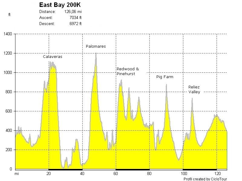
I made a couple of changes to the route over time, the most significant one between Martinez and Lafayette. After Martinez the route now goes back down Alhambra Valley Road then heads southeast on Reliez Valley Road back to Pleasant Hill Rd. RVR is a nice road, infinitely more pleasant than Taylor Blvd, although there is that stinker of a hill just before the end. So it goes. At least it's mostly flat or slightly downhill after that. Sort of.

The major climbs are Calaveras Rd, Palomares Rd, Redwood/Pinehurst/Canyon Rds, Alhambra Valley Rd (Pig Farm Hill) & Reliez Valley Rd, for a total elevation gain of about 7000 ft.

Here's the route on Bikely (click here for the more detailed map):


South Bay 215K


My South Bay 215K permanent was just approved by RUSA.

Update 10/13: Due to road construction and repaving on Silver Creek Valley Rd (SCVR) between miles 26-30, I strongly recommend that riders use the multiuse trail that runs alongside SCVR. This multiuse trail - some may call it a sidewalk :^) - is known as the Silver Creek Trail. By all indications bikes are perfectly legit on this trail; however, you will of course need to be aware and careful of pedestrians also using this trail.

Here's the route on Bikely (click here for the more detailed map):


Bikely's elevation chart shows about 3400 ft of climbing, but I'm listing it as 4000 ft in the RUSA database until someone actually rides the whole thing and proves otherwise. I'd rather overestimate than underestimate the amount of climbing.

At any rate, it should be considerably easier than my East Bay 200K. It might not be as scenic (although parts will still be very nice), but the roads will generally be good, with especially fun descents down Silver Creek Valley Rd in San Jose* and Woodside Rd in Woodside.

*Update 10/5: I drove out to Silver Creek Valley Road today and yes, the surface of the entire length of the road has been ground away for resurfacing. Signs say that the estimated completion is July 2009. RATS!!! I'd rather not take the route over this road, particularly over the long downhill section. I thought I might need to re-route up Hassler Parkway, which is a stinker of a climb, but I may be able to use the Silver Creek Trail instead. I'll do a test ride this coming weekend and submit the change to the RUSA permanents coordinator for approval.
Sunday, September 21, 2008

Ooops, I did it again

Or, amazing was a difference 30 degrees makes.

Since it looks like my new "flat" permanent route won't be approved for another week or so, I went & rode my EB200K again today.

Unlike two weeks ago, when V & I rode it during a record heat wave (smart, we were not), this weekend was lovely with nice cool temps.

Two weeks ago when I reached the mile 75 point I was thinking to myself "50 more miles? No way!!" and promptly made a beeline for the Orinda BART station. But today when I reached that same spot I was thinking "50 more miles? No problem!"

And I felt remarkably good at the end. Now if I could only climb a bit faster ....

More later. I need some shuteye.

Tuesday, September 9, 2008

Another permanent route in the works

(updated 9/9): I plotted out a new permanent route and submitted it to RUSA yesterday. The route will start out in Fremont near the BART station, head southward through San Jose and down to Gilroy, back up along the reservoirs and through Los Gatos, Saratoga, Portola Valley & Woodside, and then cross over the Dumbarton Bridge back to Fremont. It'll be about 134 miles (215K) and have less than 4000 ft of climbing. yay.

I plan to call it the South Bay 215K. Clever, huh?

Here's the route so far.